

FEMA Flood Map for Trinidad Way
Information as of 22 June 2020
When in doubt, contact your insurance agent.
This map (click to enlarge or shrink) is extracted from the Collier County
reference site,
which has gotten fancier over the years and is now difficult to use:
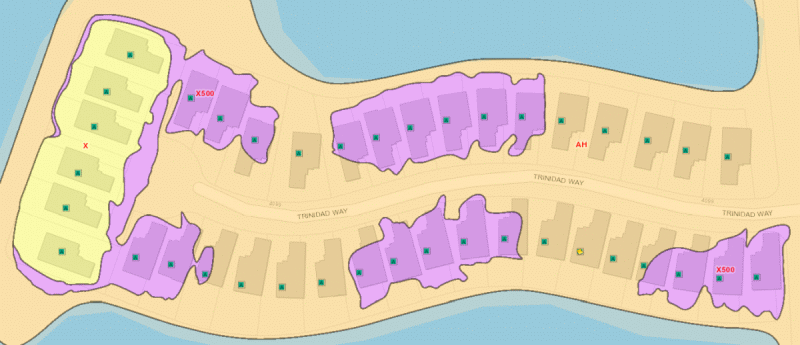
Three different codes affect Trinidad Way - zone “AH” (gold ) for many of us, zone “X500” (purple ) for some, and zone “X” (yellow ) for the rest of us. Note that your bank, if you have one, can require insurance purchase independent from these designations. It is also possible that having any portion of the lot within a lower-rated zone may cause the entire property to be considered within that zone. Your insurance agent is your best source of correct information for your specific property. The full text of the document describing the zones is found here, with excerpts as follows:
6. What is a “100-year flood” and how is it different from a “1-percent-annual-chance flood” or a “base flood?”
The term “100-year flood” is misleading. It is not the flood that will occur once every 100 years. Rather, it is the
flood that has a 1-percent chance of being equaled or exceeded each year. Thus, the 100-year flood could occur more than
once in a relatively short period of time or even within the same month. Because this term is misleading, FEMA has also
defined it as the “1-percent-annual-chance flood.” The “1-percent-annual-chance flood” is the term that is now used by
most Federal and State agencies and by the National Flood Insurance Program.
8. What are the different flood hazard zone designations shown on a Flood Insurance Rate Map (FIRM), and what do they mean?
| Zone AH (gold ) |
|---|
| Zone AH is the flood insurance rate zone used for areas of 1-percent-annual-chance shallow flooding with a constant
water-surface elevation (usually areas of ponding) where average depths are between 1 and 3 feet. BFEs derived from
detailed hydraulic analyses are shown at selected intervals within this zone. Mandatory flood insurance purchase
requirements apply. |
| Zone X (shaded) (X500 - purple ) |
| Zones X (shaded) are areas of 0.2-percent-annual-chance floodplain, areas of 1-percent-annual-chance (base flood)
sheet flow flooding with average depths of less than 1 foot, areas of base flood stream flooding with a contributing
drainage area of less than 1 square mile, or areas protected from the base flood by levees. No BFEs or depths are
shown in this zone, and insurance purchase is not required. |
| Zone X (unshaded) (yellow ) |
| Zones X (unshaded) are flood insurance rate zones used for areas outside the 0.2-percent-annual-chance (a.k.a. 500-year flood) floodplain. No BFEs or depths are shown in this zone, and insurance purchase is not required. |
There are also some rules (check with your insurance agent) regarding grandfathered insurance rates. It's not completely clear whether a FIRM was in effect when Triniday Way was built; the last revision was in 2005. Either way, the published information would seem to indicate that anyone who presently carries flood insurance should not have to be concerned about the new map, as long as they maintain coverage ‑ but don't miss the comment on Preferred Risk as well. The following is excerpted from the full rules, where “community” refers to Collier County:
To recognize policyholders who have remained loyal customers of
the NFIP by maintaining continuous coverage and/or
who have built in compliance with the FIRM, the
Federal Insurance and Mitigation Administration has “Grandfather
rules” to allow such policyholders to benefit in the rating for that
building....
Pre-FIRM (construction prior to the
date of the community's initial FIRM)
1. If a policy was obtained prior to the effective date of a map change,
the policyholder is eligible to maintain the prior zone and base flood
elevation as long as continuous coverage is maintained. The policy can be
assigned to a new owner at the option of the policyholder…
Post-FIRM (construction on or after
the date of the community's initial FIRM)
1. If a policy was obtained prior to the effective date of a map change,
the policyholder is eligible to maintain the prior zone and base flood
elevation as long as continuous coverage is maintained. The policy can be
assigned to a new owner at the option of the policyholder…
While this all appears to sound good regarding rates, the following “kicker” is added. This states that on the date of each renewal, Preferred Risk policies may only be written for buildings in class X – there are no classes of B or C in the new maps – or in the old maps, for that matter:
Preferred Risk Policies
1. Buildings written on Preferred Risk Policies are required to be located
in zones B, C, or X on the FIRM in effect on the date of application and on
the date of each subsequent renewal.
2. A building, which becomes ineligible for a Preferred Risk Policy due to
a map change to a special flood hazard area, can be rewritten on a standard
rated policy using zones B, C, or X.
Site and page designs copyright © 2002-2026; all rights reserved
Disclaimer: “This web site contains information and opinions
gathered from sources believed to be reliable.
Any of the information and/or opinions may be wrong.”
Kenneth W. Brown, 4057 Trinidad Way, Naples, FL 34119
FBO Trinidad Way Neighborhood, IslandWalk 2025-04-15